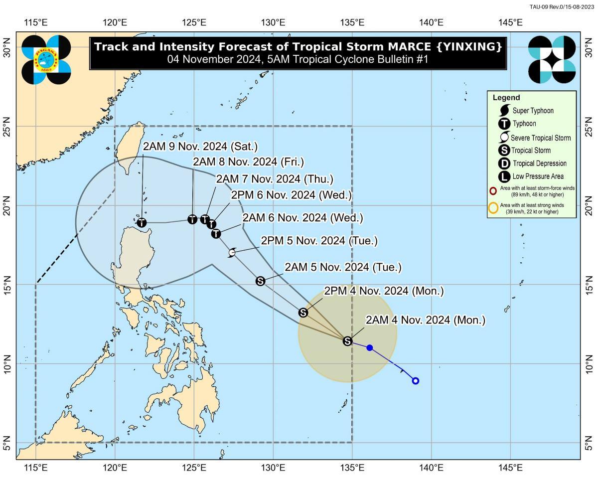
A tropical depression located east of Visayas developed into a tropical storm as it entered the Philippine Area of Responsibility on Monday morning. It has been named Marce (international name: Yinxing), PAGASA said. At 4 a.
m., the center of Marce was estimated to be located at 935 km east of Eastern Visayas. Marce has maximum sustained winds of 65 km/h near the center, gustiness of up to 80 km/h, and central pressure of 1002 hPa.
It is moving west northwestward at 25 km/h. From its center, strong to gale-force winds are extending outwards up to 380 km. PAGASA said it has not raised any Tropical Cyclone Wind Signals (TCWS) at this time.
However, TCWS No. 1 may be raised over parts of Cagayan by Tuesday. The highest TCWS that may be raised as Marce passes is TCWS No.
4 Marce may enhance the surge of the northeasterly wind flow within the week, the weather bureau said. "This, and the trough of the tropical cyclone, will bring rains over Extreme Northern Luzon and the eastern section of Luzon beginning tomorrow or on Tuesday," it added. Strong to gale-force gusts may be expected on Monday in the following areas due to the northeasterly wind flow, especially in coastal areas and upland areas exposed to winds: Batanes, Cagayan including Babuyan Islands, Isabela, Ilocos Norte, Aurora, and the northern portion of Quezon.
Coastal waters will be rough in the seaboards of Batanes and Ilocos Norte. "Mariners of small seacrafts, including all types of motorbancas, are advised not to venture out to sea under these conditions, especially if inexperienced or operating ill-equipped vessels," PAGASA said. The seas will be moderate meanwhile over the following: "Mariners of motorbancas and similarly-sized vessels are advised to take precautionary measures while venturing out to sea and, if possible, avoid navigation under these conditions," PAGASA said.
Track, intensity outlook "MARCE is forecast to move west northwestward to northwestward until Wednesday (6 November) morning before it begins to decelerate significantly while turning westward," the weather bureau said. It may move north northwestward to westward at a slow pace over the Philippine Sea east of Extreme Northern Luzon starting Wednesday afternoon until the end of the forecast period. However, there are two possible scenarios that may occur, PAGASA said: "either (1) the tropical cyclone will move more westward towards Extreme Northern Luzon or mainland Luzon or (2) the tropical cyclone will move erratically over the Philippine Sea east of Extreme Northern Luzon.
" "As such, this portion of the track forecast is highly likely to change in the succeeding advisories or bulletins," PAGASA added. Marce may also take a westward shift within the next 24 hours due to a high pressure area north of the storm. "As such, the landfall scenario may change from Babuyan Islands down to Isabela area," PAGASA said.
Marce may reach severe tropical storm category by Tuesday morning or afternoon, and typhoon category by Tuesday evening or Wednesday early morning. PAGASA advised the public and disaster risk reduction and management offices concerned to take the necessary measures to protect life and property. The weather bureau will issue the next bulletin at 11 a.
m. —KG, GMA Integrated News.


