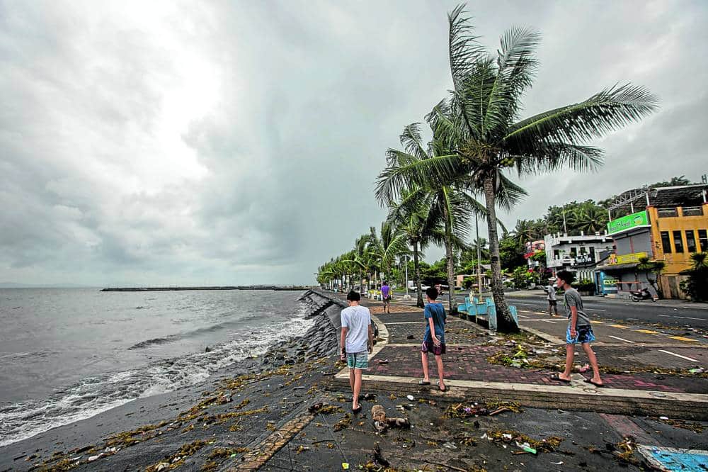
MANILA, Philippines – Super Typhoon Pepito (Man-yi) passed over the waters north of Camarines Norte’s Calaguas Islands and was already over the sea east of Quezon early Sunday morning, November 17. The Philippine Atmospheric, Geophysical, and Astronomical Services Administration (PAGASA) said in its 8 am bulletin on Sunday that Pepito is moving northwest at 15 kilometers per hour (km/h). The super typhoon is expected to keep moving east of Quezon on Sunday morning, then may pass close to or over the province’s Polillo Islands by late morning.
So far, Pepito still has maximum sustained winds of 185 km/h and gustiness of up to 255 km/h. At its peak, Pepito had maximum sustained winds of 195 km/h. During this time, it made landfall in Panganiban, Catanduanes, at 9:40 pm on Saturday, November 16, then moved offshore again.
There are no more areas in the Visayas under a tropical cyclone wind signal as of 8 am on Sunday. All areas still under Signal Nos. 1 to 5 are in Luzon.
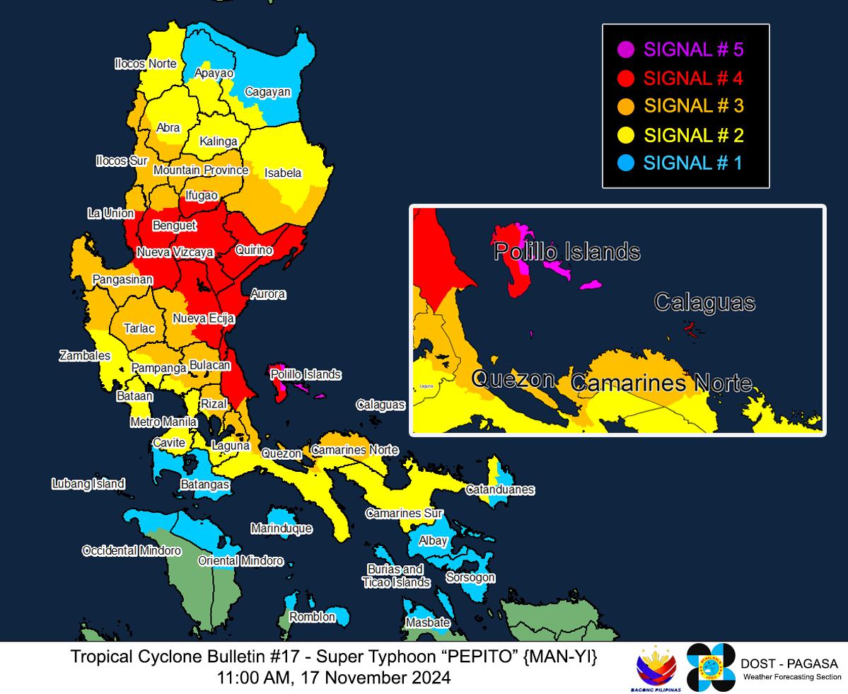
Signal No. 5 Typhoon-force winds (185 km/h), extreme threat to life and property eastern part of Polillo Islands (Patnanungan, Jomalig) Calaguas Islands Signal No. 4 Typhoon-force winds (118 to 184 km/h), significant to severe threat to life and property northernmost part of Camarines Sur (Siruma) rest of Camarines Norte northern part of mainland Quezon (General Nakar, Infanta) rest of Polillo Islands central and southern parts of Aurora (Dingalan, San Luis, Maria Aurora, Baler, Dipaculao, Dinalungan) eastern part of Nueva Ecija (General Tinio, Gabaldon, Laur, Bongabon, Palayan City, Pantabangan, Rizal, General Mamerto Natividad) southeastern part of Nueva Vizcaya (Alfonso Castañeda) southern part of Quirino (Nagtipunan) Signal No.
3 Storm-force winds (89 to 117 km/h), moderate to significant threat to life and property northern part of Camarines Sur (Sipocot, Ragay, Magarao, Del Gallego, Libmanan, Naga City, Bombon, Lupi, Cabusao, Calabanga, Goa, San Jose, Lagonoy, Presentacion, Caramoan, Garchitorena, Tinambac, Canaman, Camaligan) western part of Catanduanes (Caramoran, Pandan, San Andres) eastern part of Quezon (Calauag, Guinayangan, Tagkawayan, Lopez, Quezon, Perez, Alabat, Gumaca, Plaridel, Atimonan, Mauban, Sampaloc, Real) eastern part of Laguna (Santa Maria, Famy, Mabitac, Pakil, Pangil, Siniloan, Paete, Kalayaan, Lumban, Cavinti) eastern and central parts of Rizal (Pililla, Tanay, Antipolo City, Rodriguez, Baras, San Mateo, Morong, Teresa) rest of Aurora eastern and central parts of Bulacan (Norzagaray, San Miguel, San Ildefonso, San Rafael, Doña Remedios Trinidad, Angat, San Jose del Monte City, Santa Maria, Pandi, Baliuag, Bustos, Pulilan, Plaridel) northeastern part of Pampanga (Candaba, Arayat, Magalang, San Luis, San Simon, Mexico, Santa Ana, Apalit, Santo Tomas, San Fernando City, Mabalacat City, Angeles City) rest of Nueva Ecija Tarlac northern part of Zambales (Santa Cruz, Candelaria, Masinloc, Palauig) rest of Nueva Vizcaya rest of Quirino southern part of Isabela (San Agustin, Jones, Echague, San Guillermo, Angadanan, Alicia, San Mateo, Ramon, San Isidro, Santiago City, Cordon) central and southern parts of Ilocos Sur (Alilem, Sugpon, Cervantes, Suyo, Tagudin, Narvacan, Quirino, Sigay, Gregorio del Pilar, San Emilio, Santa Cruz, Salcedo, Banayoyo, Candon City, Galimuyod, Santa Lucia, Lidlidda, Santa Maria, Burgos, Santiago, San Esteban, Nagbukel) La Union Pangasinan Benguet Ifugao western part of Mountain Province (Sabangan, Bauko, Tadian, Bontoc, Sagada, Besao, Sadanga, Barlig) southern part of Abra (Tubo, Luba, Pilar, Villaviciosa, San Isidro) Signal No. 2 Gale-force winds (62 to 88 km/h), minor to moderate threat to life and property Albay northern part of Marinduque (Santa Cruz, Boac, Mogpog, Torrijos) rest of Quezon rest of Laguna rest of Rizal Cavite northern part of Batangas (Tanauan City, Santo Tomas, Talisay, Lipa City, Malvar, Balete, Mataasnakahoy, Laurel, Padre Garcia, San Juan, Rosario) Metro Manila Bataan rest of Pampanga rest of Bulacan rest of Zambales southwestern part of Cagayan (Enrile, Tuao, Solana, Tuguegarao City, Piat, Rizal) rest of Isabela rest of Abra southern part of Apayao (Conner, Kabugao) Kalinga rest of Mountain Province rest of Ilocos Sur southern part of Ilocos Norte (Pinili, Batac City, Banna, Nueva Era, Badoc, Currimao, Marcos, Solsona, Dingras, Sarrat, Paoay, Laoag City, San Nicolas) Signal No. 1 Strong winds (39 to 61 km/h), minimal to minor threat to life and property northern part of Masbate (Masbate City, Mobo, Aroroy, Baleno) including Ticao Island and Burias Island Sorsogon rest of Marinduque northern part of Romblon (Cajidiocan, San Fernando, Magdiwang, Romblon, Banton, Corcuera, Concepcion, San Andres, Calatrava, San Agustin) northern part of Oriental Mindoro (Puerto Galera, San Teodoro, Naujan, Baco, Victoria, Socorro, Pinamalayan, Gloria, Pola, Calapan City) northern part of Occidental Mindoro (Sablayan, Santa Cruz, Mamburao, Abra de Ilog, Paluan) including Lubang Islands rest of Batangas rest of mainland Cagayan rest of Apayao rest of Ilocos Norte Meanwhile, Pepito is still bringing moderate to torrential rain on Sunday.
Floods and landslides remain possible. Sunday, November 17 Intense to torrential rain (more than 200 millimeters): Quezon, Aurora, Camarines Sur, Camarines Norte, Nueva Vizcaya, Quirino Heavy to intense rain (100-200 mm): Catanduanes, Isabela, Nueva Ecija, Benguet, Pangasinan, Ifugao, La Union, Bulacan, Rizal Moderate to heavy rain (50-100 mm): Albay, Sorsogon, Metro Manila, Bataan, Tarlac, Pampanga, Laguna, Cagayan, Mountain Province, Zambales, Kalinga, Abra, Ilocos Sur Monday, November 18 Moderate to heavy rain (50-100 mm): La Union, Pangasinan, Zambales, Ilocos Sur In addition, there is a high risk of “life-threatening” storm surges “with peak surge heights exceeding 3 meters” in the Ilocos Region (western coast), Isabela, Central Luzon, Metro Manila, Calabarzon, Marinduque, and Bicol within 48 hours. View the map below, and check the list of specific cities and municipalities here .
After passing close to or over Quezon’s Polillo Islands, Pepito could make another landfall in northern Quezon or central or southern Aurora on Sunday afternoon. Before making its second landfall, it could be downgraded to a typhoon. “Afterwards, Pepito will cross the northern portion of Central Luzon and the southern portion of Northern Luzon along the upland areas of [the] Sierra Madre, Caraballo, and Cordillera Central [mountain ranges] between [Sunday] afternoon and evening,” PAGASA said.
During that period when it crosses mainland Luzon, Pepito might weaken into a severe tropical storm. Pepito is expected to exit landmass and emerge over the coastal waters of Pangasinan or La Union on Sunday evening or early Monday morning, November 18, then head for the West Philippine Sea and finally leave the Philippine Area of Responsibility by Monday morning or afternoon. “Further weakening over the West Philippine Sea is likely due to the incoming northeasterly wind surge,” added the weather bureau.
PAGASA updated its outlook for coastal waters in the next 24 hours. The weather bureau also reiterated that wave heights in affected seaboards are “not related to storm surge heights or inundation.” Up to very rough, high, or very high seas (travel is risky for all vessels) Northern and eastern seaboards of Polillo Islands; seaboard of Aurora – waves up to 14 meters high Seaboard of Camarines Norte – waves up to 12 meters high Seaboard of northern Quezon – waves up to 9 meters high Seaboard of Isabela – waves up to 8 meters high Northern and eastern seaboards of Catanduanes; northern seaboard of Camarines Sur – waves up to 7 meters high Eastern seaboards of mainland Cagayan, Camarines Sur, and Albay; remaining seaboards of Polillo Islands and Catanduanes – waves up to 5 meters high Seaboards of Sorsogon and Northern Samar; eastern seaboard of Eastern Samar; remaining seaboards of Camarines Sur, Albay, and Quezon; seaboards of Ilocos Region, Masbate including Burias Island and Ticao Island, and Marinduque – waves up to 4.
5 meters high Up to rough seas (small vessels should not venture out to sea) Seaboards of Batanes, northern Cagayan including Babuyan Islands, and Zambales – waves up to 4 meters high Seaboards of Romblon; remaining seaboards of Zambales; eastern seaboard of Oriental Mindoro – waves up to 3 meters high Up to moderate seas (small vessels should take precautionary measures or avoid sailing, if possible) Western seaboard of Bataan; eastern seaboard of Dinagat Islands – waves up to 2.5 meters high Seaboards of Metro Manila, Aklan, Antique, northeastern Iloilo, northern Negros Occidental, and northern Cebu including Bantayan Islands, and Biliran; northern and eastern seaboards of Leyte; eastern seaboards of Southern Leyte, Surigao del Sur, and Davao Oriental; northern and western seaboards of Dinagat Islands; remaining seaboards of Bataan and Calabarzon; northern seaboards of Occidental Mindoro including Lubang Islands and Oriental Mindoro – waves up to 2 meters high Pepito is the Philippines’ 16th tropical cyclone for 2024. It is also the fourth tropical cyclone for November alone, after Marce (Yinxing) , Nika (Toraji) , and Ofel (Usagi) .
Counting from October 21 to present — starting with Kristine (Trami) and Leon (Kong-rey) — Pepito is already the country’s sixth tropical cyclone in less than a month. – Rappler.com.


