 4 days Ago
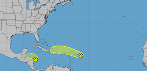
From the National Hurricane Center. Facebook Twitter WhatsApp SMS Email Print Copy article link Save Two low-pressure systems stirring in the Caribbean Sea and the Atlantic Ocean could develop more, though the likelihood of one continuing to form is slim, according to the National Hurricane Center in Miami. A disturbance spotted Monday afternoon by forecasters is currently slamming the western Caribbean with showers and thunderstorms.
Heavy rainfall will continue through the weekend, specifically across portions of Central America and southern Mexico, forecasters said in a 7 a.m. update.
Some gradual development of this system is possible over the course of two days as it moves inland over Central America. The chance of the disturbance forming in the next couple of days or within a week is 20%. Meanwhile, a system several hundred miles east of the Leeward Islands is causing disorganized showers and thunderstorms over the northern Atlantic.
Forecasters predict that the disturbance will slow develop as it moves westward to west-northwestward at around 20 mph in the next few days. Then, it is expected to pass near the Virgin Islands and Puerto Rico by Friday before closely approaching Hispaniola and the southeastern Bahamas on Saturday. Forecasters said that strong upper-level winds should halt further development.
The system has a 20% chance of developing in two days and a 30% chance of developing in a week. Neither systems pose an immediate threat to Louisiana. Don't miss a storm update this hurricane season.
Sign up for hurricane update newsletters. Follow our Hurricane Center Facebook page..