Tropical Cyclone Wind Signal (TCWS) No. 5 is still raised over the eastern portion of the Polillo Islands while Super Typhoon Pepito (international name: Man-Yi) maintained its strength late Sunday morning, according to PAGASA. TCWS No.
5 covers the municipalities of Burdeos, Patnanungan, and Jomalig. They are expected to face typhoon-force winds with speeds of 185 km/h or higher in the next 12 hours, posing extreme threat to life and property. Meanwhile, the following areas were under TCWS No.
4, as of 11 a.m.: These areas may face typhoon-force winds ranging 118 to 184 km/h in the next 12 hours that may have significant to severe threat to life and property.
Meanwhile, TCWS No. 3 was raised over these areas: Storm-force winds ranging 89 to 117 km/h may face these areas in the next 18 hours, resulting in moderate to significant threat to life and property. TCWS No.
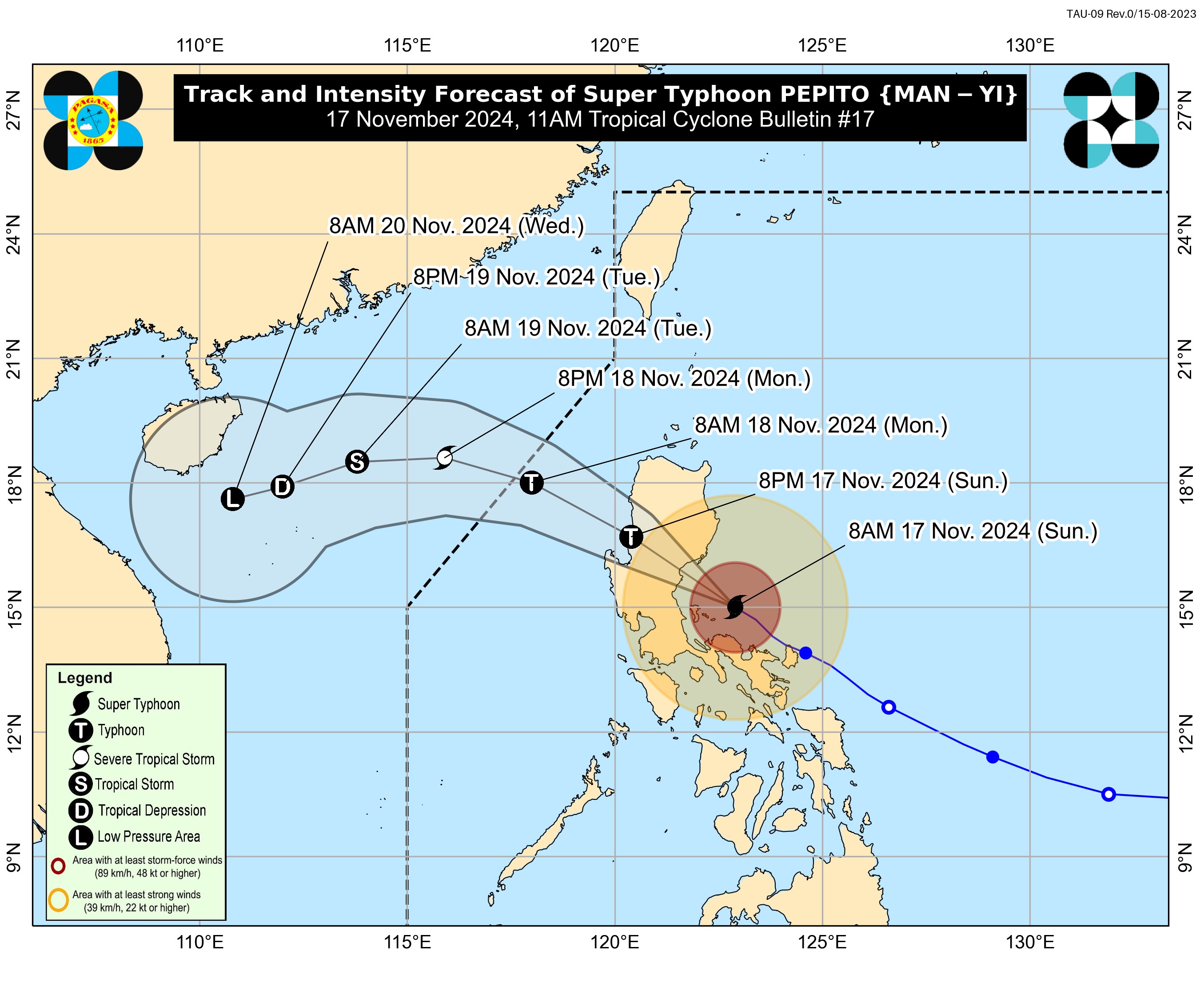
2 was raised in these areas: They may experience gale-force winds ranging 62 to 88 km/h in the next 24 hours, with wind impacts possibly resulting in minor to moderate threat to life and property. TCWS No. 1, on the other hand, was raised over the following areas: The center of the eye of Pepito was last seen 120 km East Southeast of Baler, Aurora, with a maximum sustained winds of 185 km/h near the center and gustiness of up to 230 km/h.
Coastal waters According to PAGASA, there is a high risk of life-threatening storm surge with peak surge heights exceeding 3.0 m in the next 48 hours over the low-lying or exposed coastal localities of Ilocos Region (western coast), Isabela, Central Luzon, Metro Manila, Calabarzon, Marinduque, and Bicol Region. A gale warning was also hoisted over the eastern and western seaboards of Luzon.
Track, intensity Pepito is expected to move generally west northwestward or northwestward and is seen to make landfall in the vicinity of Aurora on Sunday afternoon. Afterwards, it will cross the northern portion of Central Luzon and the southern portion of Northern Luzon via the upland regions of the Sierra Madre, Caraballo, and Cordillera Central between this afternoon and evening. The tropical cyclone is also forecast to exit the landmass of Luzon on Sunday night.
Over the West Philippine Sea, Pepito will continue moving generally west northwestward on Monday. It may exit the Philippine Area of Responsibility (PAR) region by Monday morning or noon. Outside the PAR region, the tropical cyclone will turn more westward or west southwestward on Tuesday under the influence of an incoming northeasterly wind surge.
Heavy rainfall, severe winds, and storm surge may still be experienced in localities outside the landfall point and the forecast confidence cone, said PAGASA. The track may also still shift within the limit of the forecast confidence cone. Pepito is also seen to slightly weaken as a typhoon prior to its second landfall.
Significant weakening will occur during the passage of this tropical cyclone over mainland Luzon within the day. PAGASA said that further weakening will also occur as Pepito moves over the West Philippine Sea due to the incoming northeasterly wind surge. —Giselle Ombay/RF, GMA Integrated News.


