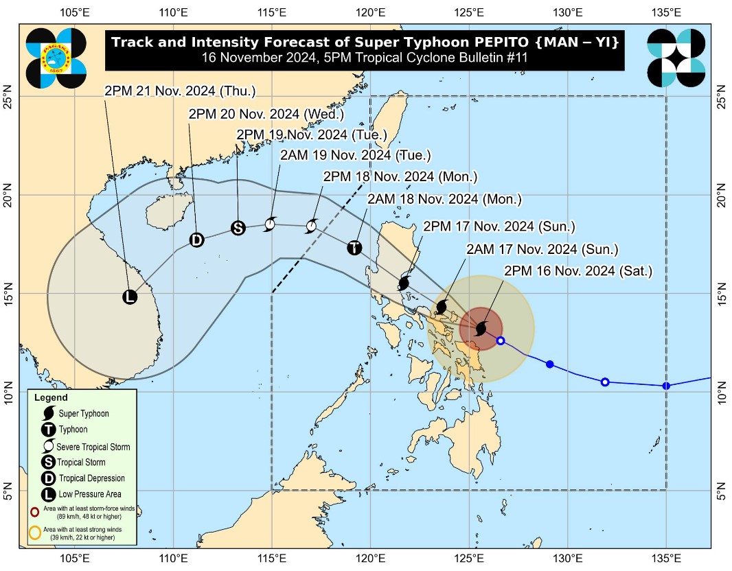
Catanduanes and part of Camarines Sur are now under Signal No. 5 due to Super Typhoon Pepito as weather bureau PAGASA maintained its warning of a "potentially catastrophic and life-threatening situation" at the northeastern part of Bicol Region. According to PAGASA's 5 p.
m. bulletin on Saturday, Pepito was last seen at 120 kms east of Virac, Catanduanes. It packed maximum sustained winds of 195 kph and gusts of up to 240 kph.
Typhoon-force winds, with speeds of 185 kph or higher within the next 12 hours, were reported in the following areas currently under Signal No. 5: Signal No. 4 was hoisted in the following areas, which are expected to experience typhoon-force winds with speeds of 118 kph to 184 kph in the next 12 hours: Storm-force winds, with speeds of 89 kph to 117 within 18 hours, were forecast in these areas under Signal No.
3: Meanwhile, Signal No. 2 is in effect over the following areas as winds of 62 kph to 88 kph were expected within 24 hours: Lastly, the following areas under Signal No. 1 may experience winds of 39 kph to 61 kph within the next 36 hours: A gale warning has also been raised over the eastern and southern seaboards of Luzon and the eastern seaboard of Visayas.
Super Typhoon Pepito is likely to make landfall in the vicinity of Catanduanes on Saturday evening or Sunday morning. However, PAGASA said the landfall location may still change. "Considering the limits of the forecast confidence cone, a landfall scenario over the eastern coast of Camarines Sur or Albay during the same time frame (if it moves slightly south of forecast track), or along the eastern coast of Quezon or Aurora tomorrow afternoon (Sunday) or evening remains [and is] not ruled out," the advisory read.
"It must be emphasized that heavy rainfall, severe winds, and storm surge may still be experienced in localities outside the landfall point and the forecast confidence cone," it added. Pepito is nearing its peak intensity, PAGASA said. Although it may begin to maintain or slightly decrease intensity in the coming hours, PAGASA said it may resume intensifying prior to passage over Catanduanes.
"PEPITO will likely make landfall over Catanduanes as a super typhoon at or near peak intensity, and as a super typhoon or typhoon over the Quezon-Aurora area. Significant weakening will occur during the passage of PEPITO over mainland Luzon tomorrow, but it will likely remain as a typhoon until it reaches the West Philippine Sea," PAGASA said. The weather disturbance is expected to exit the Philippine Area of Responsibility by Monday.
"Considering these developments, the public and disaster risk reduction and management offices concerned are advised to take all necessary measures to protect life and property. Persons living in areas identified to be highly or very highly susceptible to these hazards are advised to follow evacuation and other instructions from local officials," PAGASA advised. Meanwhile, Tropical Depression Ofel was last seen at 195 kms northwest of Itbayat, Batanes with maximum sustained winds of 45 kph and gustiness of up to 60 kph.
Ofel is currently not affecting any parts of the country, and is about to make landfall in Southern Taiwan. — VDV, GMA Integrated News.


