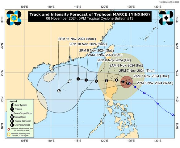
The northeastern portion of mainland Cagayan remains under Signal No. 3 as Typhoon Marce is starting to become almost stationary over the waters east of Northern Cagayan, state weather bureau PAGASA said. According to PAGASA’s 5 p.
m. cyclone bulletin, Marce was last seen 295 kilometers east of Aparri, Cagayan with maximum sustained winds of 150 kph near the center and gustiness of up to 185 kph. It is moving slowly in a westward direction.
While the northeastern portion of mainland Cagayan, including Santa Ana and Gonzaga will be seeing winds of 89 kph up to 117 kph over the next 18 hours under Signal No. 3, the following areas may anticipate winds of 62 kph to 88 kph over the next 24 hours under Signal No. 2 The following areas under Signal No.
1 may expect winds of 39 kph to 61 kph or intermittent rains within 36 hours: The typhoon is predicted to make landfall as it passes over Babuyan Islands or the northern portions of mainland Cagayan, Ilocos Norte, and Apayao by Thursday afternoon to Friday early morning, before exiting the Philippine Area of Responsibility (PAR) on Friday evening. Marce may reach peak intensity before passing over the Babuyan Channel within Wednesday, but will remain under typhoon category throughout the forecast period. —Jiselle Anne Casucian/AOL, GMA Integrated News.


