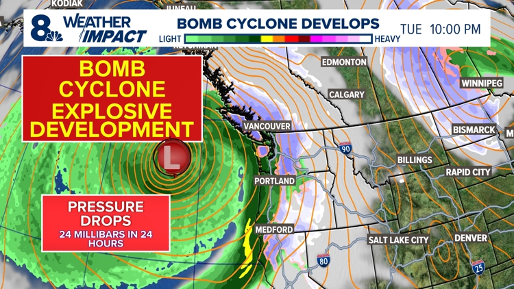
PORTLAND, Ore. — Portlanders are bracing for an incoming windstorm set to hit the entire Willamette Valley overnight Tuesday, caused by a "bomb cyclone" storm off the coast. It's an impressive term — but what does it actually mean? And just how bad is the weather about to get? Bomb cyclones are strong storms that can spin up off of both the west and east coasts, and they tend to get a lot of attention because of the name.
The term has been in use among meteorologists for decades, KGW chief meteorologist Zaffino explained, but it broke more into the mainstream in recent years. Atmospheric pressure is measured in millibars, and while the average surface pressure across the whole planet is about 1,013 millibars, there's some natural variation into areas of higher or lower pressure. Storms are low pressure areas , because the stormy weather is caused by surrounding higher-pressure air getting pulled into the low pressure system.

Bomb cyclones occur when the core of a storm undergoes a rapid pressure drop that meteorologists call "explosive" development, Zaffino said, also sometimes called "bombogenesis" — hence, the name. Lower pressure in the core translates into higher wind speeds for the storm. The development is considered explosive if the pressure at the core drops at least 24 millibars in 24 hours.
The current low pressure system off the coast of the Pacific Northwest was projected to go from about 1,014 millibars as of Monday morning to about 950 millibars on Tuesday, according to Zaffino, far more than the minimum to be considered a bomb cyclone. A strong bomb cyclone can produce wind gusts as high as 95 mph, but despite the explosiveness of this particular system, the Portland area is only expected to see gusts top out at around 45 mph overnight Tuesday — definitely impactful, but not disastrous. There are a couple of reasons for that.
Meteorologists in the Pacific Northwest generally keep an eye on the 130 degrees west longitude line, according to Zaffino, which is about 300 miles out from the coast to the west of Portland. If a storm is projected to cross east of that line, there's trouble brewing. In this case, the storm will get close to the line, but the core will remain firmly to the west of it, Zaffino explained.
That's still close enough for the outer edge of the system to hit western Washington and Oregon, but not close enough for those areas to experience super high winds. The storm's position relative to Portland also limits the strength of the winds that can hit the city Tuesday night. The storm's isobar lines — concentric rings on meteorology maps that show the change in pressure moving out from the core — are oriented north-south over Portland, which sets up an easterly wind.
"To get really strong winds in the Willamette Valley, you want to see low pressure go inland to our north, and you want to see these isobars oriented more east-west. That's a strong south wind," Zaffino explained. "So the setup isn't perfect for a strong wind event in the valley — but because this thing is so strong and close enough, we're still going to get some good winds.
" The local weather still won't be pleasant, but anyone worried about travel impacts ahead of Thanksgiving can rest easy; the storm is expected to weaken on Wednesday morning and then move back to the west on Thursday, Zaffino said. "That's typical for really strong storms along the west coast here," he said. "They'll spin up, they'll get close, and then they kind of roll on back to the west like that.
".


