 1 week Ago By Mike Drew for Postmedia
My passport had expired. Apparently, it had run out back in May but I hadn’t noticed, not having had any need to since I last crossed the border back in 2017. But now, with a customs officer checking it at the Montana border, I found out, much to my dismay, the passport was no longer valid.
Fortunately, he very courteously told me not to worry. The officers have the discretion to allow entry up to six months after a passport has expired. Kindly, he let me cross.

I was headed down there for two reasons. First off, I love Montana. It’s gorgeous — essentially an extension of southern Alberta — and the people are kind and welcoming.
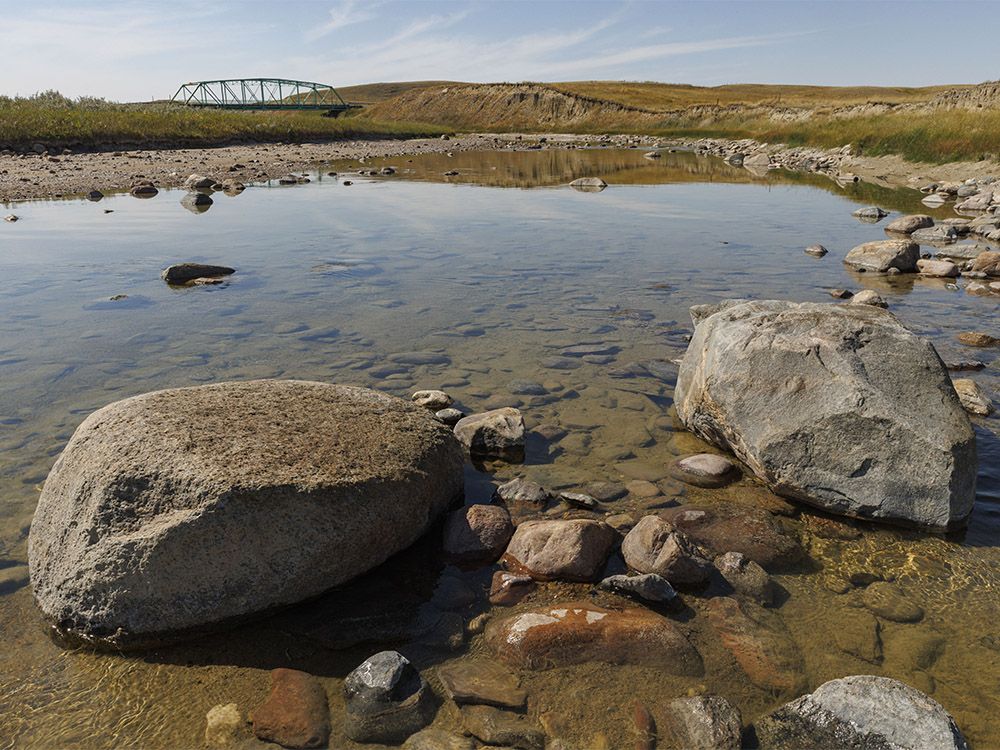
But second, and more importantly, I was concerned about the catastrophically low flow of the Milk River. I’d seen first-hand how low the water was at the . This dream of a rodeo arena sits among sandstone cliffs and is embraced by a curve of the undulating Milk River.
The rodeo itself is great but one of the things I like best about it is watching the kids and horses splashing in the silty waters of the river. This year, though, there was very little to splash in. In fact, the river was at its lowest level in nearly a century.
OK, this is going to need a little explaining. The Milk River is unique in Alberta in that it is not part of the Saskatchewan River system. Instead, its waters flow into the Missouri River and then on to the Mississippi River before hitting the Gulf of Mexico.
You could technically get in a canoe at Writing-On-Stone and then paddle all the way to New Orleans. Glacier National Park in Montana holds the headwaters of the river but it then flows north across the border and through southern Alberta before entering Montana again near the Saskatchewan border. Its fluvial neighbour, the St.
Mary River, also starts in Montana and then flows north across the border into Alberta. The difference is that the St. Mary, thanks to a low ridge between the two watersheds, flows into the Saskatchewan River system which then empties into Hudson Bay.
The two river systems are maybe 20 kilometres apart but they flow in opposite directions. As they have for millennia. But in the 1920s, a group on the Montana side figured they were losing out on the water that flowed north into Alberta so they devised a scheme where they would take a portion of the flow of the St.
Mary River and divert it into the Milk River. That way they could get back some of the water they “lost” to Alberta. To do that, they built a weir just south of the border that channels St.
Mary River water into a canal that runs into a huge set of siphon pipes that carries the flow to the North Fork of the Milk River. From there, it runs downstream through southern Alberta and brings extra water to American farming and ranching outfits back on the Montana portion of the river. Work on the canal and siphon was finished in 1924 and the water has flowed since then.
Until this past June when the siphon failed. The pipes burst open and a deluge tore apart the remaining parts of the siphon as well as the hillside it ran down. As a result, the Milk River is no longer getting the St.
Mary River water. Essentially, it’s back to its natural flow from a century ago. Which ain’t very much.
So I crossed the border to have a look at the blown-out siphon and to start exploring this unique watershed. The St. Mary River, the source of the extra water, starts in a series of lakes on the northeastern side of Montana’s Glacier National Park.
From there it makes a short run to the north and crosses the border just south of Cardston. The weir that channels the water over to the Milk River sits near the tiny town of Babb and the canal runs from there back to the St. Mary River valley just a few kilometres from the Carway/Peigan border crossing where it delivers the water to the siphon.
Or, used to. The canal is dry now, as it has been since mid-June. And the siphon is gone.
But folks on the Montana side are hard at work rebuilding it. Excavation work is being done and it looks like the project is rolling along. They claim it will be rebuilt and back in use sometime in 2025.
In the meantime, though, both rivers are back to their mostly natural states. Which is to say, low. Like all rivers, once spring runoff has finished and the dry summer season starts, river levels start to drop.
That’s pretty normal and we see it here on the Bow and Elbow Rivers. The St. Mary River running past Kimball and Cardston is also low, though maybe not quite as low as it would have been with the Montana siphon still intact.
But it is flowing lovely and clear on its way to Hudson Bay. The Milk River, on the other hand, is the opposite. The water that’s in the river now won’t likely ever see the Gulf of Mexico.
Though the St. Mary weir has always been shut down for the winter, the summer months have seen the North Fork of the Milk River running from bank to grassy bank. Having spent my formative years splashing around in its waters, fishing in its cutoff meanders and generally just enjoying its presence, I have fond memories of its silty flow.
But for now, that flow is gone. I’d started too late in the day to really begin exploring the Milk River so after crossing the ridge that separates the two watersheds I drove on into the darkness over to Del Bonita where I had planned to stop for the night. But as I reclined the seat and looked out the windshield, I saw two things nearly simultaneously.
One was the time — barely 9:30 — and the second was all the stars. I could sleep later. Time to try some night pictures.
This is dark country. Farms and ranches are few and far between and there are no towns except tiny Del Bonita between Cardston and Milk River. So stopping by a rural bridge over the Milk River, I had nothing but starlight to take pictures by and nothing to hear but the burble of the river and night birds calling.
Oh, and one very loud fuel truck heading back from the fields. I shot it crossing the bridge but once it was gone, the night filled back in. A few hours of fitful sleep later I was back to the river to watch the sun rise.
And as it did, I got my first good look at how low the water is. There were gravel bars showing everywhere, pools in the deeper spots were still fairly full but between them the flowing water was narrow enough to step over. I flew my little drone around to see it from above and the lack of water was startling.
But as I looked at it on the drone’s monitor, it struck me that maybe this might be how it should look at this time of year. Those gravel bars and sinuous bends have been carved out of the land by both the north and south forks of the Milk River since the decline of the last ice age. In fact, it is the decline of the last ice age that created this valley.
The Milk River Ridge, the second of Alberta’s two continental divides, exists because the great ice sheets that once covered Alberta ended here and dropped the huge load of ground-up rock they were carrying. When the ice finally melted, the St. Mary River flowed on one side and the Milk River flowed on the other.
And until a century ago, the two systems were separate. Each carved its own path in its own way. But with the siphon carrying water across the divide, that changed.
The Milk River was kept artificially full. At the town of Milk River, the flow was winter-time low — I hope their taps aren’t running dry — and at Gold Springs Park just downstream, the water was shallow enough to wade in. The spring-fed pond there was full, though, and a squadron of goldfinches was chasing bugs and splashing in the warm river waters.
As was I, both here and downstream by Coffin Bridge. The day had turned hot — 33C at mid-afternoon — so I wandered along the river bed and waded in the shin-deep water. The flow itself was uncharacteristically clear, the silt load usually carried by the high water nonexistent with the low flow.
As a result I could see all the colours of the pebbles and sand on the bottom and found glacier-scattered boulders that I hadn’t known existed here. And lots of little fish. Sitting on one of those boulders with the water flowing around my shoes, I looked down through my lens at the minnows — dace, I think — that came flooding in every time I moved my feet.
Must have been something in the sand that was getting stirred up when I moved. Above Writing-On-Stone, the exposed river bottom was gravel and the sweeping bends were more constrained by those honey-coloured sandstone ridges but downstream from the park where the valley opens up again it was almost completely sand. And the cattle were loving it.
A hundred or so were lolling along the grassy banks or resting on the sand bars in the river. Some waded through the water that seemed to be even more shallow here. If it was shin-deep up by Coffin Bridge, it would barely be ankle-deep here.
These pools used to be full of sauger — a fish related to walleye — and the former Alberta record for the biggest one was actually caught in the Milk River. There’s no way there would be any here now. Night was closing in now and with it a change in the weather.
Clouds were coming in from the west and bringing with them smoke from fires in Idaho. But as darkness settled I stopped to take a picture of the Milky Way over the Milk River valley and then again back at Coffin Bridge. And in the dark, once again, I listened to the river burble and the night birds call.
And I thought, ya know, we made this Milk River what it is. We took water from another river and put it here to, really, just satisfy ourselves. We created an artificial environment that we in this part of southern Alberta and our neighbours in Montana have come to depend on.
And I loved that version of the Milk River. But having seen it now, back to — more or less — its natural state, I kinda love that, too. But it will be short-lived.
By this time next year or maybe the summer after, St. Mary River water will be bolstering the Milk River again. And these low flows will be gone.
So this jaunt along the Milk River has been kind of a trip back in time, back to an era when this part of Alberta was as it has always been. A truly once-in-a-lifetime experience. And that, my friends, has been a privilege.
.