 9 hours Ago By T.J. Muscaro
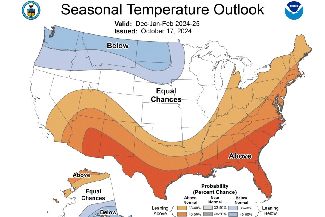
The meteorological winter season runs from December 2024 through February 2025. During that time, NOAA gives Florida, Texas, and the rest of the Gulf Coast the highest probabilities for warmer-than-normal temperatures. The administration said it expected below-average temperatures for the Pacific Northwest, Northern Rockies, and Northern Plains from Washington state to Minnesota.
The District of Columbia metro area is expected to have higher-than-normal temperatures. Regarding rainfall, the Pacific Northwest and the Great Lakes regions are predicted to receive above-average precipitation this winter, while drought-like conditions are expected to intensify and spread across the Gulf Coast, Southwest, and Great Plains. The Pacific Northwest, northern and central Rockies, and parts of Northern California are expected to get above-average snowfall, along with the Great Lakes and Northern Plains.
However, central states are expected to see less snow this winter, and NOAA officials specifically called out Colorado, Texas, Oklahoma, and Kansas. Along the Eastern Seabord, the coastal cities are expected to retain higher temperatures, resulting in more rain and ice events. However, further inland, above-average snowfall is expected in the mountains of New England.
Brad Pugh, operational drought lead with NOAA’s Climate Prediction Center, told The Epoch Times: “Snowfall composites based on past La Nina winters depict above-normal snowfall for the northern Rockies and northern New England.” Snow was reported to be falling on the mountains of North Carolina on Oct. 16, but Pugh said: “There is not a clear signal for what snowfall will be across the southern Appalachians.
” Looking beyond winter, the forecast appears to be optimistic for spring skiing. Below-normal temperatures and above-normal precipitation are also favored for the Pacific Northwest and northern Rockies during February, March, and April, “which would imply a prolonged snow season,” Pugh told The Epoch Times. Jon Gottschalck, Operational Prediction Branch Chief of NOAA’s Climate Prediction Center, told the media: “High variability or frequent week-to-week changes are more likely this winter as compared to more persistent or prolonged periods of more consistent weather conditions.
” Developing in the Pacific Ocean, La Nina brings colder waters to the ocean surface, pushing the jet stream to the north. This causes warmer-than-normal temperatures in the south and colder-than-normal temperatures in the north. NOAA forecasts a 70 percent chance of La Nina development by November, and Gottschalck told reporters that the lack of a strong La Nina made forecasting this winter difficult compared to last year’s defined El Nino.
“We do have less confidence, and some of the impacts may not be as wide-ranging as maybe typical, let’s say, with the strong La Nina,” he said. “But in general, certainly with the forecast, it was more difficult this year than, say, last year, where we had a very strong El Nino, and [with] that particular phase and strength, we had a lot more reliability and impact.”.