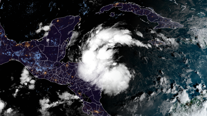
Editor’s Note: Read our new story for the latest updates on Tropical Storm Sara. Tropical Storm Sara is expected in the Caribbean soon and will deliver “life-threatening” impacts to parts of Central America as it begins a journey that could once again bring a tropical threat into the Gulf of Mexico. Forecasters at the National Hurricane Center are urging residents of the eastern Gulf Coast, including Floridians, to monitor the forecast closely because the storm could reach the US next week.
Soon-to-be Sara is another example of an Atlantic hurricane season that hasn’t played by the rules. Tropical activity should be winding down in November, but this will be the third named storm this month instead thanks to exceptionally warm water wrought by climate change. For now, it is Tropical Depression Nineteen with 35 mph maximum sustained winds and is located 65 miles east of the Honduras/Nicaragua border in the Caribbean Sea, according to the NHC.

The storm will strengthen as it meanders and nearly stalls over the very warm water of the western Caribbean Sea — the same body of water that fueled Hurricane Rafael — and will be a tropical storm while near the northern coast of Honduras over the weekend. Tropical storm alerts have been issued for parts of Honduras and Nicaragua, with the storm’s wind and rain expected to arrive as soon as Thursday evening and ramp up Friday. The storm will bring “life-threatening” flooding rainfall up to 30 inches to Honduras and double-digit rainfall totals to other parts of Central America, the NHC warned.
That could mean “widespread areas of life-threatening and potentially catastrophic flash flooding and mudslides.” It will then threaten Belize and the Yucatán Peninsula with storm surge and gusty winds by early next week, so residents should prepare. The potential impacts on the eastern Gulf of Mexico, including Florida, the Florida Keys, and Cuba, remain uncertain, and those in these areas should closely monitor forecasts because the forecast becomes extremely uncertain beyond this weekend.
US threat? There are a few potential scenarios on the table for how formidable the storm could be and whether it could reach the US next week. They all hinge on how close Sara gets to the coast of Honduras over the next few days. The official forecast from the hurricane center has the system skimming along the coast of Honduras over the weekend, but this could change.
If it makes landfall in Honduras this weekend and moves far enough inland, it could deteriorate while over land, cut off from the warm water fueling it. This scenario would bring strong winds and torrential rain to Central America, but could keep the storm away from the US entirely or have it approach as a very weak storm. If Sara remains very close to the coast of Central America, but briefly moves over land, it could eventually emerge in the southern Gulf of Mexico next week as a weak, but slightly stronger storm than in the first scenario.
This scenario would lessen the blow if it were to reach the US. It would still unleash life-threatening flooding rainfall in Central America and head for dangerous strike on Belize and Mexico’s Yucatán Peninsula But if the system stays far enough away from the coast and over the Caribbean’s tremendously warm water, it could strengthen considerably — and possibly rapidly intensify . This would bring more substantial impacts to Central America, the Yucatán and Belize and a much more troubling forecast for the US.
Sea surface temperatures in the Caribbean are currently their second-warmest on record — just behind 2023’s record-breaking heat. They’re warmer than they should be at the peak of hurricane season and could continue to produce unusually strong storms. Warmer bodies of water are fueling stronger storms and more rapid intensification as the world warms due to fossil fuel pollution.
Sara could make a gradual turn to the northwest after it exits Central America, head for a powerful strike on the Yucatán and potentially reach the eastern Gulf of Mexico as a much stronger storm that could make a run at Florida next week. The Gulf is record-warm for this time of year and likewise could boost or sustain any system that reaches it. All scenarios are still possible, but forecast models are starting to agree that the storm will get much closer to the Honduras coast than initially thought Wednesday, making the more troubling scenario less likely.
Five hurricanes have slammed into the US Gulf Coast this year. If this system were to make landfall in the US, it could challenge the latest landfalling hurricane on record. The current record rests with Hurricane Kate, which made landfall as a Category 2 storm in Florida on November 21, 1985.
Hurricane season officially comes to an end on November 30, but named storms have formed in December in the past..


