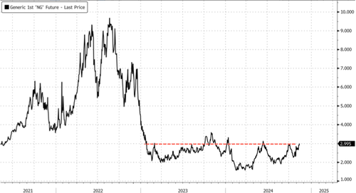
US natural gas futures are up 2.5% in late afternoon trading, reaching $2.98 per mmBtu, driven by new forecasts showing a shift in cold weather from the West Coast to the East next week.
This suggests households may crank up their thermostats for the first time this season as a proper chill sets in. Private weather forecaster BAMWX published a new mid-day GEFS run for late November that shows "massive cold trends" for the eastern half of the US. "The pattern supports the cold stretch and we have a better tap to cold air ahead," BAMWX wrote on X, adding, "Could get pretty interesting for a time late month for wintry potential.
" Massive colder trends on the mid-day GEFS run for late November. The pattern supports the cold stretch and we have a better tap to cold air ahead. Could get pretty interesting for a time late month for wintry potential.
#Energy #NatGas #OOTT $ng $ung pic.twitter.com/UpJ5pT44t8 Meteorologist Ryan Kane wrote on X, "It's safe to say next weeks ULL will be the big pattern changing system (Nov 20-23rd).
Nice -EPO, +PNA & -NAO will all work to drive cold into the eastern half of CONUS." "Snow potential should come Thanksgiving week as the -NAO attempts to break down as the cold air is established," Kane noted. It's safe to say next weeks ULL will be the big pattern changing system (Nov 20-23rd).
Nice -EPO, +PNA & -NAO will all work to drive cold into the eastern half of CONUS. Snow potential should come thanksgiving week as the -NAO attempts to break down as the cold air is established pic.twitter.
com/thWrHJDSZZ BAMWX said the pattern shift to much cooler temps in the interior Northeast could produce ripe conditions for snow next week. ❄SNOW CHANCES ARRIVING AROUND THANKSGIVING? For several days now, we've been mentioning the pattern changing with cooler temperatures arriving for the end of November/start of December. With the cooler temperatures, comes the possibility of winter precipitation👀 Now.
.. snow.
.. pic.
twitter.com/ZPQEy24iqB Here's what other meteorologists are saying..
. Euro Ens (upgraded) showing a strong signal for wintery mischief here in the Mid Atlantic going into Thanksgiving week. 👇 It even has a little snow in the Baltimore Metro.
Take that with a grain of rock salt, but all of the long-range modeling is seeing the cold air. Stay tuned pic.twitter.
com/pwvsoKiJs7 eye candy euro control with Thanksgiving week snowstorm in interior east pic.twitter.com/VYm3V0Vn6Q Back to NatGas fundamentals, here's the latest data (courtesy of Bloomberg): Weather: Forecasts shifted cooler for parts of the West Coast with colder temperatures moving eastward later in the Nov.
18-22 period: Maxar See WHUT for a map of latest 6-10 day weather forecast: NOAA * Click here for two-week temperature forecasts for the US Storage: Gas inventories probably rose 39 bcf last week, based on median of analyst estimates compiled by Bloomberg Five-year average gas inventory change for week ended Nov. 8 is +29 bcf Stockpiles totaled 3.932 tcf as of Nov.
1, 5.8% above the five-year average EIA to report weekly storage data at 10:30am New York time on Thursday Daily BNEF Gas Data: Lower-48 dry gas production on Wednesday ~100.4 bcf/day, or -5.
2% y/y Lower-48 total gas demand ~81.7 bcf/day, or -3.1% y/y Dry gas exports to Mexico ~6.
5 bcf/day, or -2% w/w Estimated gas flows to LNG export terminals ~13.7 bcf/day, or +1.5% w/w Maybe a cold blast in the Northeast and other parts of the US will be the catalyst to push NatGas futures past the $3 mark, which has served as strong resistance for nearly two years.
In mid-August, the 208th edition of the Farmers' Almanac published the " Wet Winter Whirlwind ." It noted , " There will be a lot of precipitation and storms"—all dependent on location." And this: NatGas Bulls Rejoice: Colder Winter Lower 48 Forecasts May "Place Upward Pressure" On Prices.
NatGas Prices Near Breakout Level Ahead Of Cold Blob Invasion
NatGas Prices Near Breakout Level Ahead Of Cold Blob Invasion US natural gas futures are up 2.5% in late afternoon trading, reaching $2.98 per mmBtu, driven by new forecasts showing a shift in cold weather from the West Coast to the East next week. This suggests households may crank up their thermostats for the first time this season as a proper chill sets in. Private weather forecaster BAMWX published a new mid-day GEFS run for late November that shows "massive cold trends" for the eastern half of the US. "The pattern supports the cold stretch and we have a better tap to cold air ahead," BAMWX wrote on X, adding, "Could get pretty interesting for a time late month for wintry potential." Massive colder trends on the mid-day GEFS run for late November. The pattern supports the cold stretch and we have a better tap to cold air ahead.Could get pretty interesting for a time late month for wintry potential. #Energy #NatGas #OOTT $ng $ung pic.twitter.com/UpJ5pT44t8— BAM Weather (BAMWX) (@bamwxcom) November 13, 2024Meteorologist Ryan Kane wrote on X, "It's safe to say next weeks ULL will be the big pattern changing system (Nov 20-23rd). Nice -EPO, +PNA & -NAO will all work to drive cold into the eastern half of CONUS.""Snow potential should come Thanksgiving week as the -NAO attempts to break down as the cold air is established," Kane noted. It's safe to say next weeks ULL will be the big pattern changing system (Nov 20-23rd). Nice -EPO, +PNA & -NAO will all work to drive cold into the eastern half of CONUS. Snow potential should come thanksgiving week as the -NAO attempts to break down as the cold air is established pic.twitter.com/thWrHJDSZZ— Ryan Kane (@ryankanerWX) November 13, 2024BAMWX said the pattern shift to much cooler temps in the interior Northeast could produce ripe conditions for snow next week. ❄SNOW CHANCES ARRIVING AROUND THANKSGIVING?For several days now, we've been mentioning the pattern changing with cooler temperatures arriving for the end of November/start of December.With the cooler temperatures, comes the possibility of winter precipitation👀Now... snow... pic.twitter.com/ZPQEy24iqB— Kirk 🇺🇸 Hinz | BAM ⚡️Weather (@Met_khinz) November 12, 2024Here's what other meteorologists are saying...Euro Ens (upgraded) showing a strong signal for wintery mischief here in the Mid Atlantic going into Thanksgiving week. 👇 It even has a little snow in the Baltimore Metro. Take that with a grain of rock salt, but all of the long-range modeling is seeing the cold air. Stay tuned pic.twitter.com/pwvsoKiJs7— Tony Pann (@TonyPannWBAL) November 13, 2024eye candy euro control with Thanksgiving week snowstorm in interior east pic.twitter.com/VYm3V0Vn6Q— The American Storm (@BigJoeBastardi) November 8, 2024Back to NatGas fundamentals, here's the latest data (courtesy of Bloomberg):Weather:Forecasts shifted cooler for parts of the West Coast with colder temperatures moving eastward later in the Nov. 18-22 period: MaxarSee WHUT for a map of latest 6-10 day weather forecast: NOAA * Click here for two-week temperature forecasts for the USStorage:Gas inventories probably rose 39 bcf last week, based on median of analyst estimates compiled by BloombergFive-year average gas inventory change for week ended Nov. 8 is +29 bcfStockpiles totaled 3.932 tcf as of Nov. 1, 5.8% above the five-year average EIA to report weekly storage data at 10:30am New York time on ThursdayDaily BNEF Gas Data:Lower-48 dry gas production on Wednesday ~100.4 bcf/day, or -5.2% y/yLower-48 total gas demand ~81.7 bcf/day, or -3.1% y/yDry gas exports to Mexico ~6.5 bcf/day, or -2% w/wEstimated gas flows to LNG export terminals ~13.7 bcf/day, or +1.5% w/wMaybe a cold blast in the Northeast and other parts of the US will be the catalyst to push NatGas futures past the $3 mark, which has served as strong resistance for nearly two years.In mid-August, the 208th edition of the Farmers' Almanac published the "Wet Winter Whirlwind." It noted, "There will be a lot of precipitation and storms"—all dependent on location." And this: NatGas Bulls Rejoice: Colder Winter Lower 48 Forecasts May "Place Upward Pressure" On Prices Tyler DurdenWed, 11/13/2024 - 17:20