Nearly two dozen tornado warnings were in effect Wednesday night, from Arkansas to Indiana, with many more expected as an intense storm system moved in, per the National Weather Service.The big picture: Damage was reported from multiple confirmed tornadoes, with the threat expected to last through the night in the Mid-South and parts of the Midwest and Ohio Valley. In Arkansas, Gov.
Sarah Huckabee Sanders declared a state of emergency ahead of the storms to provide funding in response to the severe weather. "We have reports of storm and tornado damage from around the state," she said on X Wednesday night.Tornado damage was also reported in Washington County, Missouri, on Wednesday evening.

8:18 PM - Multiple tornado warnings in effect, we are about to shelter in place here at the office!!! pic.twitter.com/l2XDmAucVz— NWS Paducah, KY (@NWSPaducah) April 3, 2025Threat level: In addition to tornadoes, rainfall totals from dangerous flooding could reach a few Aprils' worth in just four to five days in the hardest-hit areas.
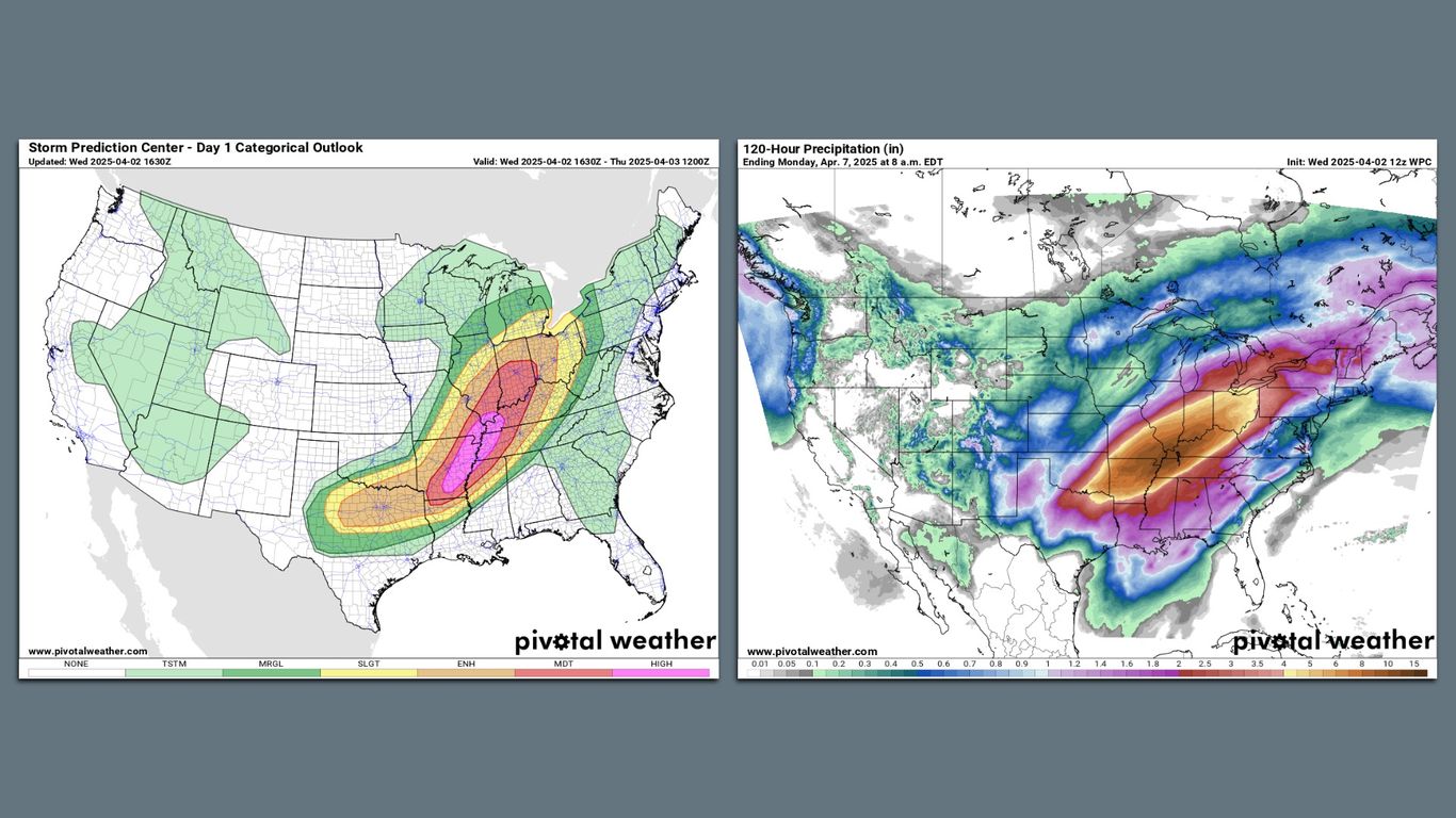
The National Weather Service warned of an "increasingly significant setup" with the potential for "catastrophic" flooding in the hardest-hit regions.It forecast rainfall totals that could exceed 15 inches in some locations, describing it as an "extreme flooding scenario."Forecasters will be closely watching as rains add up in the Mid-South, particularly across northeastern Arkansas, northwestern Tennessee and western Kentucky.
The NWS forecast office in Memphis warned of "Generational flooding" in northwestern Tennessee, saying on X, "This is a rare, high-impact, and potentially devastating event."State of play: The flooding is only one of this upcoming storm's hazards, as a powerful and slow-moving low-pressure area slides across the Central states and Midwest.Severe thunderstorms with the threat of damaging winds and a large-scale, "major" tornado outbreak are forecast on Wednesday and Wednesday night across the Mid-South.
The Storm Prediction Center is predicting a "high risk" — or level 5 out of 5 on its scale — of severe weather in the mid-Mississippi Valley to the Lower Ohio Valley on Wednesday into Wednesday night, including the threat of "[n]umerous tornadoes, along with multiple long-track EF-3+ tornadoes." Cities in the high risk zone include Memphis and Jonesboro, Tenn., with Louisville, Little Rock, Ark.
, Indianapolis, Evansville, Ind., and Bloomington, Ind., in the moderate risk zone.
As of Wednesday afternoon, tornado watches were in effect for more than a half-dozen states in the Mid-South, including one "Particularly Dangerous Situation" tornado watch that is reserved for the most significant severe weather threats. Context: Extreme precipitation events are becoming more common and severe due to climate change, as warmer air temperatures hold more moisture.A new analysis from the nonprofit research group Climate Central found that heavy precipitation extremes are increasing in frequency in all regions of the country, though there is greater variability at the local levels.
A marine heat wave in the Gulf of America (renamed by the U.S. from the Gulf of Mexico) and the Caribbean — a phenomenon increasingly tied to climate change — is also a factor, since this area will be the moisture source region for the heavy rainfall.
In another sign of the event's unusual nature, there is the potential for some spots to set records for the amount of precipitable water in the atmosphere.This is a way of measuring the precipitation that would result if all of the moisture in a column of air were to condense and fall as rain.The extreme weather comes amid the Trump administration's push to give states the lead role in disaster response and recovery, potentially dissolving FEMA.
What we're watching: Where the heaviest rainfall sets up, and how severe the ensuing flooding gets.Editor's note: This a breaking news story. Please check back for updates.
.


