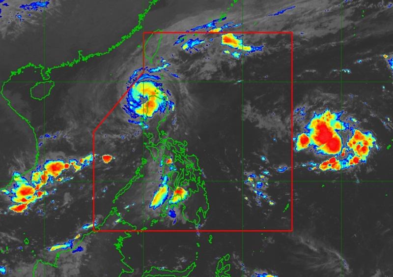
Typhoon Marce is now over the sea west of Ilocos Norte, with five areas still under Signal No. 4, and expected to exit the Philippine Area of Responsibility (PAR) this afternoon, according to the Tropical Cyclone Bulletin PAGASA posted early Friday morning. The center of Typhoon Marce was estimated to be over the coastal waters of Pasuquin, Ilocos Norte packing maximum sustained winds of 155 kilometers per hour near the center and gustiness of up to 215 kph and moving West Northwestward at the speed of 10 kph.
Tropical Cyclone Wind Signal (TCWS) No. 4 is hoisted over the following areas: TCWS No. 3 is hoisted over the following areas: TCWS No.
2 is hoisted over the following areas: TCWS No. 1 is hoisted over the following areas: Forecast Weather Conditions Ilocos Norte and Ilocos Sur will have stormy weather due to Typhoon Marce with the possibility that flooding or landslides will occur due to heavy to intense rains. Moderate to severe threat to lives and properties due to strong winds.
Cordillera Administrative Region, the rest of Ilocos Region, Batanes, and Cagayan will have rains with gusty winds due to Typhoon Marce with the possibility that flooding or landslides will occur due to heavy to at times intense rains. Minor to moderate threat to lives and properties due to strong winds Central Luzon and the rest of Cagayan Valley will have cloudy skies with scattered rains and thunderstorms due to the trough of Typhoon Marce with the possibility that flooding or landslides will occur due to moderate to at times heavy rains. Metro Manila and the rest of the country will have partly cloudy to cloudy skies with isolated rain showers or thunderstorms due to localized thunderstorms with the possibility that flooding or landslides will occur during severe thunderstorms.
Forecast Wind and Coastal Water Condition Northern Luzon and the western section of Central Luzon will have strong to gale wind speed moving in the southeast to east direction while coastal waters will be rough to high. The western section of Southern Luzon will have moderate to strong wind speed moving southeastward with moderate to rough coastal waters. The rest of the country will have light to moderate wind speed moving in the east to southeast direction while coastal waters will be slight to moderate.
Severe Winds There will be significant to severe impacts from typhoon-force winds are possible within any of the areas under Wind Signal No. 4, moderate to significant impacts from gale-force winds are possible within any of the areas under Wind Signal No. 3, minor to moderate impacts from gale-force winds are possible within any of the areas under Wind Signal No.
2 and minimal to minor impacts from strong winds are possible within any of the areas under Wind Signal No. 1. The northeasterly wind flow and the periphery of Marce will also bring strong to gale-force gusts over the following areas (especially in coastal and upland areas exposed to winds): Batanes, Cagayan including Babuyan Islands, Isabela, and Ilocos Region.
Coastal Inundation There is a high risk of life-threatening storm surge with peak surge heights exceeding 3.0 m in the next 48 hours over the low-lying or exposed coastal localities of Batanes, Cagayan including Babuyan Islands, Isabela, Ilocos Norte, Ilocos Sur, and La Union, said PAGASA Hazards affecting coastal waters A Gale Warning is hoisted over the seaboards of Northern Luzon. Mariners are advised to take precautionary measures while venturing out to sea and, if possible, avoid navigation under these conditions.
Track and Intensity Outlook Typhoon Marce will continue to move generally westward and exit the Philippine Area of Responsibility (PAR) region this afternoon or evening. Sunrise will be at 5:54 a.m.
, sunset at 5:26 p.m. — BAP, GMA Integrated News.


