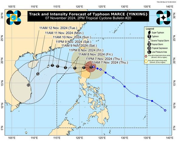
Three areas were placed under Tropical Cyclone Wind Signal (TCWS) No. 4 Thursday afternoon as Typhoon Marce intensified and moved to the coastal waters of Sta. Ana, Cagayan, state weather bureau PAGASA said.
In its 2 p.m. bulletin, PAGASA said the following areas in Luzon were under TCWS No.
4: TCWS No. 3 was hoisted over the following areas: The following areas were also placed under TCWS No. 2: Meanwhile, TCWS No.
1 is in effect in the following areas: PAGASA said the center of Marce was located over the coastal waters of Santa Ana, Cagayan moving west northwestward at 10 kilometers per hour (kph) with maximum sustained winds of 175 kph near the center and gustiness of up to 240 kph. “MARCE will be making landfall in Santa Ana, Cagayan between 2 p.m.
and 4 p.m. today,” PAGASA said.
“Afterwards, the typhoon will move generally westward, briefly emerge over Aparri Bay, and make another landfall along the coast of northwestern mainland Cagayan. MARCE will emerge over the West Philippines tomorrow (8 November) early morning,” it added. According to PAGASA, Marce could reach the super typhoon level.
“Landfall at peak intensity is expected. Reaching super typhoon category is not ruled, although this will be for a brief period only,” PAGASA said. Marce is expected to exit the Philippine area of responsibility (PAR) Friday afternoon or evening, according to PAGASA.
—AOL, GMA Integrated News.


