 8 hours Ago
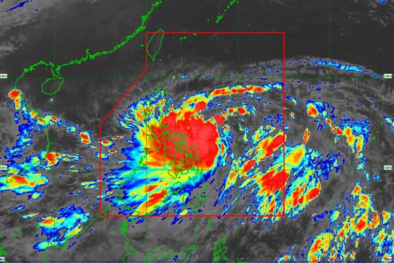
Kristine intensifies into a Tropical Storm, continues moving westward, according to the lastest Tropical Cyclone bulletin posted by PAGASA. The center of the eye was estimated at 390 kilometers east of Virac, Catanduanes packing maximum sustained winds of 65 kilometers per hour near the center, gustiness of up to 80 kph and moving westward at 15 km/h. Tropical Cyclone Wind Signal (TCWS) no.
1 is raised over the following areas: Luzon Visayas Mindanao Heavy rainfall Bicol Region, Eastern Visayas, Isabela, Quirino, Aurora, and Quezon will have rains with gusty winds due to Kristine with the possiblity that flash floods or landslides will occur due to moderate to heavy with at times intense rains. Minimal to minor threat to lives and properties due to strong winds. Metro Manila, the rest of Luzon, Visayas, Zamboanga Peninsula, Northern Mindanao, Basilan, Sulu, and Tawi-Tawi will have cloudy skies with scattered rains and thunderstorms due to the Trough of Tropical Storm Kristine with the possiblity that flash floods or landslides will occur due to moderate to heavy rains.
The rest of Mindanao will have partly cloudy to cloudy skies with isolated rain showers or thunderstorms also due to the Trough of Tropical Storm Kristine with the possiblity that flash floods or landslides will occur during severe thunderstorms. Severe Winds "The wind signals warn the public of the general wind threat over an area due to the tropical cyclone. Local winds may be slightly stronger/enhanced in coastal and upland/mountainous areas exposed to winds.
Winds are less strong in areas sheltered from the prevailing wind direction," PAGASA reported, adding that minimal to minor impacts from strong winds are possible within any of the areas under Wind Signal No. 1. The weather bureau also reported that the wind flow coming towards the circulation of Kristine and the Northeasterly Windflow will also bring strong to gale-force gusts over the following areas (especially in coastal and upland areas exposed to winds): Batanes, Babuyan Islands, Ilocos Region, Palawan, Romblon, Aklan, Antique, Negros Island Region, Central Visayas, Southern Leyte, Zamboanga del Norte, Northern Mindanao, Dinagat Islands, Surigao del Norte, Agusan del Norte, Sarangani, Davao del Sur, and Davao Oriental.
Hazards affecting coastal waters A Gale Warning is hoisted over the eastern seaboard of Luzon, the southern seaboard of Southern Luzon, and the eastern seaboard of Visayas. "Sea travel is risky all types or tonnage of vessels. All mariners must remain in port or, if underway, seek shelter or safe harbor as soon as possible until winds and waves subside," said PAGASA.
Track and Intensity Outlook "Kristine is forecast to move northwestward to west northwestward until Thursday (24 October) before turning westward for the rest of the forecast period," the bureau said. Kristine may make landfall over Isabela on Wednesday evening and may exit the Philippine Area of Responsibility by Friday evening. However, the forecast track may change, depending on the movement of the weather systems surrounding this tropical cyclone in the next few days.
Kristine, PAGASA said, is forecast to remain as a tropical storm in the next 24 hours and may reach severe tropical storm category on tomorrow and may make landfall over Isabela as a severe tropical storm. It is forecast to reach typhoon category on Friday as it emerges over the West Philippine Sea. "Since this tropical cyclone is still over the Philippine Sea, rapid intensification is not ruled out given the favorable environmental conditions," said PAGASA.
— BAP, GMA Integrated News.