 1 week Ago
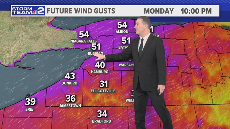
BUFFALO, N.Y. — The National Weather Service out of Buffalo has issued a High Wind Watch for most of Western New York on Monday, extending into early Tuesday morning.
The watch includes residents in Erie, Niagara, Orleans, Genesee, Wyoming, and Chautauqua Counties with projected wind gusts between 50 and 60 mph. Southwest winds will be between 30 and 40 mph with gusts up to 60 mph possible. The strongest wind gusts are expected across the Niagara Frontier.

A clipper or fast-moving low-pressure system approaches Saturday with thickening clouds and a few scattered snow showers later in the day. It will be breezy with highs in the upper 20s to near 30. Wind gusts up to 40mph will be from the SW.
Snow showers will pick up at times Saturday night with some more light snow accumulation likely, between a coating to 2 inches. Any leftover flurries will taper early Sunday with breezy conditions and highs near 30. We'll have a couple of rounds of passing snow showers around Tuesday and Wednesday next week.
No big snow is expected. We'll briefly get colder into the 2nd half of the week, however a substantial warm-up looks likely into next weekend. Stay tuned for any needed updates from Storm Team 2 .
.