 2 weeks Ago
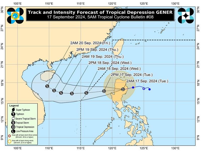
Tropical Depression Gener maintains its strength while moving westward over Northern Luzon with 24 areas under Signal No. 1 as it continues to enhance the southwest monsoon, according to the latest Tropical Cyclone Bulletin posted by PAGASA. As of 4 a.
m., the center of Tropical Depression Gener was estimated in the vicinity of Alicia, Isabela packing maximum sustained winds of 55 kilometers per hour near the center, gustiness of up to 70 kph, and central pressure of 996 hPa. Gener is moving westward at the speed of 30 kph with strong winds extending outwards up to 360 km from the center.

Tropical Cyclone Wind Signal (TCWS) No. 1 is hoisted over the following areas: Heavy rainfall is forecasted due to Tropical Depression Gener and the southwest monsoon or habagat enhanced by Gener and Tropical Storm Pulasan. Heavy Rainfall Outlook Metro Manila, Ilocos Region, Cordillera Administrative Region, Cagayan Valley, Central Luzon, Rizal, and Quezon will have rains with gusty winds due to Gener with the possibility that flash floods or landslides will occur due to moderate to heavy with at times intense rains.
Expect minimal to minor threat to lives and properties due to strong winds, the weather bureau said. Palawan, Occidental Mindoro, Aklan, Antique, and Negros Occidental will have monsoon rains due to the southwest monsoon with the possibility that flash floods or landslides will occur due to heavy to intense rains. The rest of MIMAROPA, Western Visayas, and Negros Island Region will have occasional rains due to the southwest monsoon with flash floods or landslides occurring due to moderate to heavy rains.
The rest of Luzon and Visayas, Zamboanga Peninsula, BARMM, SOCCSKSARGEN, Caraga, and Northern Mindanao will have cloudy skies with scattered rains and thunderstorms due to the southwest monsoon with the possibility that flash floods or landslides will occur due to moderate to at times heavy rains. The rest of Mindanao will have partly cloudy to cloudy skies with isolated rain showers or thunderstorms due to the southwest monsoon with the possibility that flash floods or landslides will occur during severe thunderstorms. Severe Winds PAGASA said that the wind signals warn the public of the general wind threat over an area due to the tropical cyclone and that local winds may be slightly stronger/enhanced in coastal and upland/mountainous areas exposed to winds.
Winds are less strong in areas sheltered from the prevailing wind direction. The Southwest Monsoon enhanced by Gener and Pulasan will also bring strong to gale-force gusts over the following areas (especially in coastal and upland areas exposed to winds): Batanes, MIMAROPA, Bicol Region, Visayas, and Mindanao. Hazards affecting coastal waters "Gale Warning is in effect over several coastal waters in the northern seaboard of Northern Luzon, the western and southern seaboards of Southern Luzon, the seaboards of Visayas, and the western, northern, and eastern seaboards of Mindanao," the weather bureau reported, adding that sea travel in these waters is risky for small seacrafts, including all types of motorbancas.
Track and Intensity Outlook "Gener is forecast to emerge over the coastal waters of Ilocos Sur or La Union today. The tropical cyclone will then move generally westward over the West Philippine Sea until Thursday (19 September) before turning west northwestward as it heads towards southern China," said PAGASA. Gener may exit the Philippine Area of Responsibility (PAR) between Tuesday evening and Wednesday morning.
— BAP, GMA Integrated News.