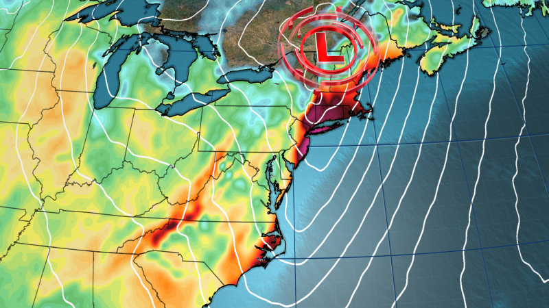
A slow-moving and strengthening storm system fueled by an atmospheric river will span the entire East Coast on Wednesday and bare down on the Northeast with the worst of its wind and rain. The storm’s sloppy mess of heavy rain and strong winds will make for treacherous travel and a miserable day in the Northeast’s major cities. Winds gusting 50 to 60 mph could also knock out power across the region, including in New York City and Boston.
The atmospheric river feeding the system will tap into the warm tropical ocean off the coast of the Southeast to create moisture levels rarely seen in the Northeast outside of tropical systems , allowing for faster rainfall rates and the potential for flash flooding. Experts are saying this will be the most moisture-rich system in the Northeast since last December when widespread flooding killed several people and caused significant damage to roads in Maine. The storm system will strengthen as it moves east Wednesday, causing winds to whip, especially in New England.

High wind alerts are in effect along the East Coast from Maryland to Maine. “Damaging winds could blow down trees and power lines. Widespread power outages are possible.
Travel could be difficult, especially for high profile vehicles,” such as buses and trucks the National Weather Service office in Boston warned. This will be the first significant rain event for much of the Mid-Atlantic and Northeast since August, so while the atmosphere is loaded with flooding rainfall potential, the ongoing drought conditions in the region, including extreme drought conditions in New Jersey, should limit widespread flooding. “The main concerns will be urban and poor drainage flooding and ponding on roadways,” forecasters with the National Weather Service office in Mount Holly, New Jersey, said.
The drought stems from a record warm and dry fall that has stretched into winter. Philadelphia hasn’t recorded more than 1 inch of rain in a day since August 6. The last time New York’s Central Park had a 2-inch soaker was August 18.
Still, the storm could dump a lot of rain, and quickly. A level 2 of 4 risk for flooding rain is posted from Long Island, New York, north through Maine with more than 1.5 inches of rain expected for much of the East Coast and more isolated pockets of 2 to 4 inches possible.
Rapid snow melt in areas in interior New England could add to the localized flash flooding concerns, especially near smaller creeks and low-lying areas. “The rivers across New England can thankfully take a decent surge of moisture after a very dry fall, so the prospects of significant flooding are lower than normal at this point,” adds the Weather Prediction Center. Another rush of Arctic air will arrive behind this storm, dropping temperatures back below normal.
Much of the Northern Plains and Midwest will wake up to below zero wind chills by Wednesday morning. This will once again trigger the lake effect snow in the Great Lakes by the middle of the week, and 1 to 2 feet of snow is possible off lakes Erie and Ontario by the end of the week..


